
11 Days
10 Nights


Manaslu, known as Katung I in Tibetan, is the world’s eighth-highest mountain and is often called the “Mountain of Spirit.”Nestled in Nepal’s Gorkha district, this majestic mountain lies at the heart of the renowned Manaslu Circuit Trek—a journey that circles the base of the mountain through remote Himalayan landscapes and timeless Tibetan-influenced villages. What makes this trek so special is its authenticity. While many other trails have become crowded and commercialized, Manaslu still feels raw and real. It’s a place where age-old traditions, pastoral lifestyles, and deep spiritual beliefs are still very much alive. If you’re seeking a quieter, more meaningful trekking experience, the Manaslu Circuit is truly unforgettable.
I can confidently say that the Manaslu Circuit is one of the finest trekking routes in Nepal. The journey starts at Machhakhola, just 890 meters above sea level, and gradually climbs to the breathtaking Larke Pass at 5,106 meters. Along the way, the climate transforms from warm subtropical zones to alpine forests and glacial terrain. Every day feels new, with constantly shifting landscapes and cultural encounters. The trail follows the Budhi Gandaki River, where you’ll pass roaring waterfalls, sway across suspension bridges, and feel the raw beauty of the region. As you gain altitude, the valley opens up, revealing sweeping mountain views, blooming rhododendron forests, and crystal-clear mountain springs. It’s a trek filled with both natural wonder and deep cultural richness.
The Manaslu Circuit Trek is located in the heart of Nepal’s Gorkha district and follows the Budhi Gandaki River as it climbs through deep valleys into the remote Nubri region, beyond the majestic Manaslu Range. From there, the trail ascends to the high-altitude Larke Pass at 5,106 meters, crossing stunning glacial landscapes before descending into the Marsyangdi Valley. This trek offers an extraordinary mix of untouched and rugged terrain, rich in biodiversity and ever-changing vegetation. Traversing through both the Manaslu Conservation Area and the Annapurna Conservation Area, trekkers experience a remarkable geographical journey—from lowland fields and river valleys to waterfalls, glacial lakes, alpine meadows, high mountain passes, and Tibetan-style highland settlements. It’s a diverse and awe-inspiring trek through Nepal’s wild and varied landscapes.
The Manaslu region in Gorkha is part of one of the youngest and most dramatic mountain ranges on Earth—the Himalayas. These towering peaks and deep valleys were formed millions of years ago when the Indian continent slowly collided with Asia. That powerful push created the massive uplift we now see as the Himalayas.
As you trek through the Manaslu Circuit, you're walking across layers of ancient Earth that have been squeezed, melted, and uplifted over time. The lower valleys are made of old river rocks, shale, and limestone, while the higher regions—especially near Samagaun and Larke Pass—are full of hard, shiny rocks like gneiss, quartzite, and granite. These rocks formed deep underground and were pushed up by the force of tectonic activity.
One special feature of this region is the Manaslu Granite, a beautiful light-colored rock that formed from molten material about 22 million years ago. It’s often seen along cliffs and peaks in the upper trail. Glaciers, rivers, and landslides continue to shape this landscape today. That's why you'll notice sharp ridges, deep gorges, and wide U-shaped valleys carved by ancient ice.
Historically and geographically, the Nubri and Tsum Valleys were once part of Tibet before the 19th century. These remote highland valleys were active trade routes connecting the Tibetan Plateau with Nepal's lowlands. Culturally, the people of Nubri and Tsum are of Tibetan origin and continue to follow Tibetan Buddhism. According to legend, the great Tibetan sage Milarepa visited the region in the 13th century, leaving a spiritual imprint that still draws pilgrims today.
The area once belonged to the ancient Gungtang Kingdom, with remnants of its fort still visible. Following the Nepal-Tibet war during the rule of Jang Bahadur Rana, the region was officially incorporated into Nepal. For centuries, the people of Nubri maintained strong trade and social ties with the lowland communities, while pilgrims from Tibet and across the Himalayas traveled to the sacred monasteries in Samagaun and Tsum. Tsum Valley, known as the “Hidden Valley of Happiness” or Beyul, holds deep religious significance.
In 1998, the Nepal government established the Manaslu Conservation Area Project (MCAP), which has played a key role in protecting the region’s biodiversity and promoting responsible tourism. Since then, the valley has drawn national and international scholars, travelers, and pilgrims alike.
The best time to trek the Manaslu Circuit is during the autumn (September to November) and spring (March to May) seasons, when the weather is generally stable, skies are clear, and the mountain views are spectacular. Summer (June to August) can also be an option, particularly in the higher Himalayan areas like Samagaun, which receive less rainfall. However, lower sections of the trail and road access points may be affected by monsoon rains and occasional landslides.
Winter (December to February) brings cold temperatures and heavy snowfall, especially near Larke Pass, which can make crossing difficult. Although autumn and spring offer the most favorable trekking conditions, weather in the Himalayas can be unpredictable year-round. That said, the Manaslu Circuit remains open throughout the year, and teahouses continue to operate even during the off-season.
If you plan to trek in the summer or winter months, we recommend including a few buffer days in your itinerary to accommodate weather-related delays. For the most accurate updates and safety guidance, it’s best to stay in close contact with your trekking guide and our support team. You can also visit our dedicated page for more insights on the best trekking seasons in Nepal.
The Manaslu Circuit Trek is considered moderately difficult and is best suited for trekkers with some experience, rather than complete beginners. The route reaches a high point of 5,106 meters at Larke Pass and involves navigating varied, often challenging terrain over the course of around 12 days or more. This combination of altitude and duration requires solid physical fitness, mental endurance, and proper preparation.
While experienced trekkers will find the Manaslu Circuit both manageable and deeply rewarding, it's important to approach this trek with respect for the high-altitude environment. Good acclimatization, understanding of altitude sickness, and prior hiking experience all contribute to a safer and more enjoyable journey. With the right mindset and support from a knowledgeable guide, even those new to high-altitude trekking can successfully complete the Manaslu Circuit. Here are some guidelines for beginners to do Manaslu Trek.
Day 1: Drive from Pokhara to Machha Khola (890m)
Day 2: Trek from Machha Khola to Jagat (1,070m) 22 km
Day 3: Trek from Jagat (1,070) to Deng (1,860m) ( 20km)
Day 5: Trek from Deng to Namrung (2,660m) ( 14km)
Day 6: Trek from Namrung to Samagaun (3,530m) (17km)
Day 7: Rest Day in Samagaun (Hike to Manaslu Base Camp or Birendra Lake or visit Pungyen Monastery)
Day 8: Trek from Samagaun to Samdo (3,875m ) (8.5 km)
Day 9: Trek from Samdo to Dharamsala (4,480m ) (6.1km)
Day 10: Trek from Dharamsala (4,480m) to Bhimtang (3,720m) by crossing Larkya la Pass (5,106m) (16 km)
Day 11: Trek from Bhimtang to Dharpani (1910m) ( 16km,8 hours ) (25 km)
The total cost for the Manaslu Circuit Trek is USD 981 per person based on a group of two. Prices may vary depending on group size- larger groups typically benefit from discounted rates, while smaller groups may have slightly higher costs.
Below is a comprehensive overview of what’s covered in the package, what’s not, and the group discount options available.
The trekking section of the Manaslu Circuit Trek itself covers around 138 kilometers over 9 days, with an average of more than 15 kilometers of walking each day. The travel distance from Kathmandu to the starting point of the Manaslu Trek at Machhakhola is approximately 160 kilometers. After completing the trek, the return journey from Dharapani back to Kathmandu covers about 212 kilometers.
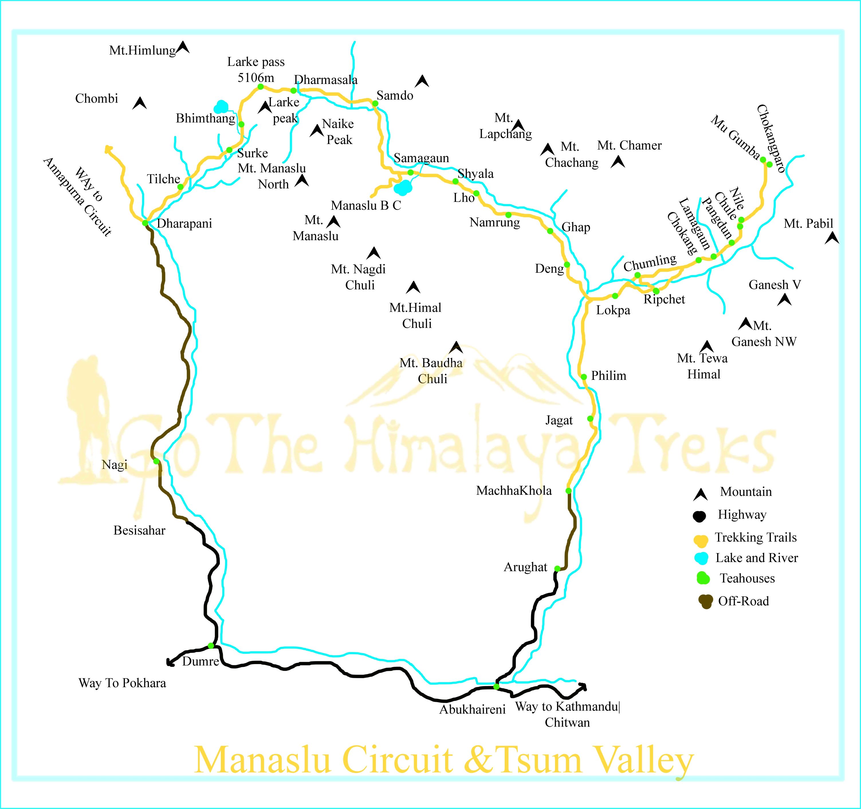
Starts- Kathmandu or Pokhara to Arubazar Gorkha- Machha Khole- Jagat- Sirdibas- Philim- Deng- Namrung-Lho-Shyala- Samagaun- Samdo- Dharamshala- Larke Pass- Bhimthang- Tilche-Dharapani-Besisahar-Dumre-Kathmandu|Pokhara -finish.
The Manaslu Circuit Trek begins at a relatively low elevation of around 600–700 meters, typically from Arughat or Machha Khola in the Gorkha district. As the trail follows the Budhi Gandaki River, it steadily gains altitude, passing through villages like Jagat (1,340m), Deng (1,860m), Namrung (2,630m), and Lho (3,180m). The altitude continues to rise as trekkers reach Shyala and then Samagaun (3,530m), an important acclimatization stop. From here, the trail climbs to Samdo (3,860m) and Dharamshala (4,460m), before crossing the highest point of the trek—Larke Pass at 5,106 meters. After the pass, the route descends sharply to Bhimthang (3,720m), eventually reaching Tilche (2,300m) and Dharapani (1,963m), where the trek concludes. This gradual ascent with proper acclimatization days is key to adjusting safely to the altitude and minimizing the risk of altitude sickness.
To trek in the Manaslu region, five permits are required: the Restricted Area Permit (RAP), Manaslu Conservation Area Permit (MCAP), Annapurna Conservation Area Permit (ACAP), a Rural Municipality entry fee, and the TIMS (Trekkers’ Information Management System) card. These permits are mandatory for all trekkers entering the region.
We can easily arrange all of these permits for you in advance, making your journey to the Himalayas smooth and worry-free. For more details about the Restricted Area Permit, you can also visit the official website of Nepal Immigration.
Follow the "Golden Rule": Gain no more than 400m-600m in sleeping elevation per day above 3,000m.
Acclimatization Days: Take full advantage of the rest day in Samagaun and consider another if you feel unwell.
Hydration: Drink plenty of water and avoid alcohol to minimize the risk of dehydration and altitude sickness
Go Slow: Walking at a steady pace helps your body adjust to the altitude more effectively.
Monitor Symptoms: Be alert to early signs of AMS (Acute Mountain Sickness) such as headache, nausea, dizziness, or loss of appetite.
Descend: If symptoms worsen, descend immediately.
Nubri Valley at Manaslu : Where Culture, Faith, and Nature Live in Harmony
Hidden deep in the Himalayan folds near Mt. Manaslu, Nubri Valley is home to a close-knit, resilient community with deep Tibetan roots. Life here is shaped by the rhythm of the mountains and the principles of Tibetan Buddhism. Villages like Sama Gaun, Lho, and Samdo offer more than just scenic beauty—they are living cultural landscapes, where tradition and spirituality continue to guide daily life.
The people of Nubri are kind-hearted and spiritually grounded. Most speak a local dialect of Tibetan and have lived in harmony with their environment for generations. Their days revolve around simple but meaningful work—farming, herding yaks, and trading with nearby regions, including Tibet.
You’ll see prayer flags fluttering in the breeze, ancient monasteries perched on hillsides, and mani walls etched with mantras like Om Mani Padme Hum. This isn’t a museum—it’s a sacred way of life, still very much alive.
Buddhism isn’t just a belief system here—it shapes everything from daily routines to seasonal festivals and life milestones. Monks (lamas) serve as spiritual guides and healers, leading ceremonies to bring peace, protect the land, and bless the people.
Places like Pungyen Gompa and Ribung Gompa offer both spiritual retreat and cultural depth. These monasteries are centers of learning, where young novices study age-old teachings amid stunning mountain vistas.
We begin with a drive from Kathmandu to Machha Khola, covering approximately 160 kilometers.
After breakfast, the day’s trek begins along the scenic trail that follows the Budhi Gandaki River. The path winds through narrow gorges, crossing suspension bridges over rushing streams and rivers, with waterfalls cascading down the surrounding cliffs. We stop at a local teahouse for lunch before continuing onward. Along the way, we pass through small villages where you can observe daily life and traditional Himalayan culture—one of the day’s true highlights.
Jagat marks the official entry point into the Manaslu Conservation Area. This charming village sits at an elevation of 1,370 meters along the banks of the Budhi Gandaki River. The trail from Jagat offers stunning scenery—deep river valleys, high suspension bridges, cascading waterfalls, and traditional hillside villages with terraced fields are some of the day’s highlights.
After walking for about 2.5 hours, we reach the picturesque village of Philim. We pause here and continue another 2 hours before stopping for lunch. The trail then continues for roughly 3 more hours, eventually bringing us to Deng, where we settle in for the night.
Deng is more of a peaceful overnight stop than a bustling village, with a few local homes scattered above a small stream. The views of Mt. Lachung and Chachung alongside the Budhi Gandaki River create a stunning backdrop.
After breakfast, we begin our day by following the Budhi Gandaki once again, crossing a suspension bridge before reaching the small hamlet of Bihi. After a short rest, we continue our scenic walk through dense pine forests, enjoying spectacular views of waterfalls and deep valleys. We cross another suspension bridge and arrive at Gyap, where we stop for lunch.
From here, the trail climbs steadily toward Namrung. Along the way, we pass an apple farm—don’t miss the chance to try some fresh apple pie! We end the day at Namrung, a beautiful village on the riverbank, where we spend the night.
As we gain elevation, the landscape and culture begin to change noticeably. The architecture shifts to Tibetan-style stone houses with timber roofs, and we begin to encounter the Tibetan-influenced people of the upper Nubri Valley. Their traditions, dress, and way of life offer a fascinating contrast to the lower regions of Nepal.
After enjoying a breathtaking sunrise over Mt. Pangboche, we begin our day with breakfast and set off on the trail. Following the Budhi Gandaki River, we continue through open valleys, passing fields of barley and potatoes, with distant monasteries and small villages visible across the riverbanks. As the valley widens, more mountain views emerge, and the settlements grow larger in size and character.
We pass through the traditional villages of Lhi and Shya before reaching Lho, where we stop for lunch. Lho is a large and lively village known for its impressive monastery and terraced fields. After lunch, we rejoin the trail, walking through a beautiful forested path alongside a stream, and begin a steady climb to the scenic village of Shyala. This charming place is dotted with monasteries and traditional homes.
From here, we gradually ascend to Samagaun, an ancient Tibetan-influenced village where we spend the night surrounded by Himalayan serenity and cultural richness.
Today is a well-deserved rest and acclimatization day in the beautiful village of Samagaun (3,530m). Surrounded by towering peaks and deep-rooted Tibetan culture, Samagaun is the heart of the Nubri Valley and an ideal place to adjust to the altitude before crossing Larke Pass.
You have a few great options for short hikes and exploration:
After an early breakfast, we begin our trek toward Samdo, a relatively easier day compared to previous ones. Along the way, we pass scenic landmarks like Birendra Lake and an old monastery—ideal stops if you missed them the day before.
The trail leads through a breathtaking valley nestled between Mt. Naike Peak and Mt. Pangboche, with sweeping alpine landscapes, yak pastures, small streams, and sparse pine forests. After about 5 hours of steady walking, we reach Samdo, the last permanent village before the Tibetan border.
We arrive in time for lunch and have the afternoon to explore. A short hike up a nearby hill is perfect for further acclimatization, offering panoramic views of the surrounding mountains. Set beneath the imposing Mt. Pangboche, Samdo provides stunning views of the lower valley, Himal Chuli, and Naike Peak. The village is rich in Tibetan culture, and the traditional highland lifestyle here is truly captivating.
As usual, we begin our day after breakfast and gradually ascend toward Dharamsala, the last overnight stop before crossing Larke Pass. Leaving behind the peaceful Samdo village and majestic Mt. Pangboche, we cross a small stream near the Nepal–Tibet border and pass a long mani wall carved with sacred prayers.
The trail continues through a broad, open valley known as Larke Bazaar, once a seasonal trading post. With Naike Peak to the left, wide yak pastures to the right, and Larke Peak straight ahead, the scenery becomes increasingly dramatic. As we climb higher, we’re rewarded with views of massive glaciers and Manaslu North, and eventually, the striking ice-covered slopes of Mt. Manaslu itself. We arrive at Dharamsala, not a village but a cluster of basic lodges offering shelter before the high pass. Though facilities are simple, the mountain views are unforgettable. We spend the night here, preparing for the big crossing tomorrow.
We begin the most challenging and rewarding day of the trek early—waking around 3:00 AM to pack and having breakfast by 4:00 AM. The trail gradually climbs along the glacial moraine, with breathtaking views of Larke Peak and the surrounding snowcapped giants glowing in the early light.
After about 4–6 hours of steady ascent, we reach Larke Pass (5,106m) just in time to witness the stunning sunrise over the Himalayas. The views from the pass are absolutely unforgettable—on one side lies Mt. Manaslu and Manaslu North, and on the descent, you'll see a new panorama featuring Mt. Himlung, Chombi, and Kangguru.
We descend carefully down the rocky trail toward Phedi, stopping for a well-deserved lunch. The glacial lakes before and at Bhimthang add serenity to the rugged terrain. After another 1.5 hours of downhill trekking, we arrive in the beautiful valley of Bhimthang, where we spend the night surrounded by alpine splendor.
This is truly one of the most breathtaking days of the trek. The wide Bhimthang Valley, with its serene glacial lake and towering views of Mt. Manaslu, creates a magical mountain setting. As the sun rises, the peaks of Himlung, Chombi, and Kangguru light up in the north, while to the south, Manaslu glows above a forested valley with winding streams—a view that feels almost heavenly.
We descend gradually through a fairytale-like forest of tall pines and blooming rhododendrons in vibrant shades of white, red, pink, and purple. Along the way, we pass charming villages like Surke, Gowa, and Tilche, each offering glimpses of local mountain life.
From Tilche, we continue down to Dharapani, where we spend the night and reflect on the incredible beauty of the journey.
After breakfast, we begin the journey back with a scenic jeep drive from Dharapani to Besisahar, descending through lush hills and traditional villages along the Marsyangdi River. From Besisahar, you can either continue by private vehicle or tourist bus to Pokhara (approx. 5–6 hours) or return directly to Kathmandu (approx. 7–9 hours), depending on your travel plan.
Your comfort is our priority


